
Coffin Peak
Last year when Carol and I were in Death Valley, time ran out before we could get up here to Dante’s View. This year, March 2019, on our annual spring trip to Las Vegas and southern Nevada, we made a point to drive directly from Las Vegas by way of Pahrump to Dante’s View. I am glad we waited because last year we would have been tired after a day of seeing the valley part of the national park. Further, last year’s sky was clear, and this year’s presented some brooding clouds to avoid the “bald-headed sky” situation I have mentioned in previous posts. This year we were greeted by snow showers, although the flakes were so minute that they were hardly noticeable. The brownish-purple lump 1 mile/1.6 kilometers in the distance is Coffin Peak at 5488 ft/1711 m ASL (above sea level) just 12 feet/3.7 meters higher than my vantage point from Dante’s View.
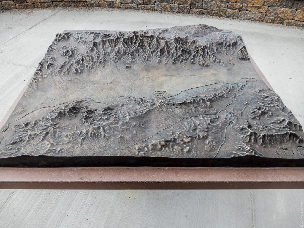
Scale Model of Central Death Valley
This miniature representation of Death Valley is on display at Dante’s View. This central part of Death Valley has the Amargosa Range on its east flank (near side) and the Panamint Range (far side) on its west flank. North is to the right. The Black Mountains make up the southern part of the Amargosa Range. Dante’s View is labeled on the tableau with Badwater Basin down the cliff from it. Now I walk just a few steps west, and we will go from the model to the real thing…!
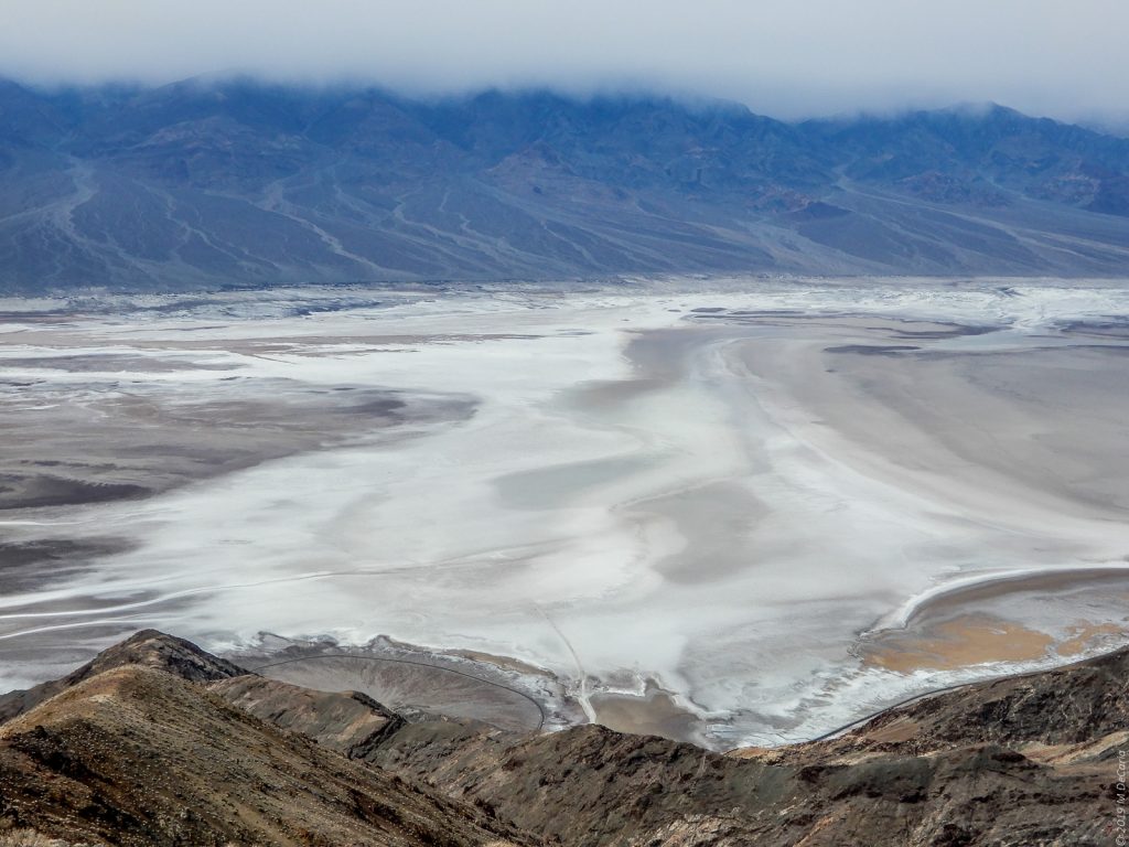
From Dante’s View Looking down at Badwater Basin and Across Death Valley to the Panamint Range.
Just beyond edge of the cliff in the bottom, exact center of the photo is a drop of 5758ft/1755 m when you consider that Dante’s View is 5476 ft/1669 m ASL and Badwater Basin is 282 ft/86 m below sea level (BSL).
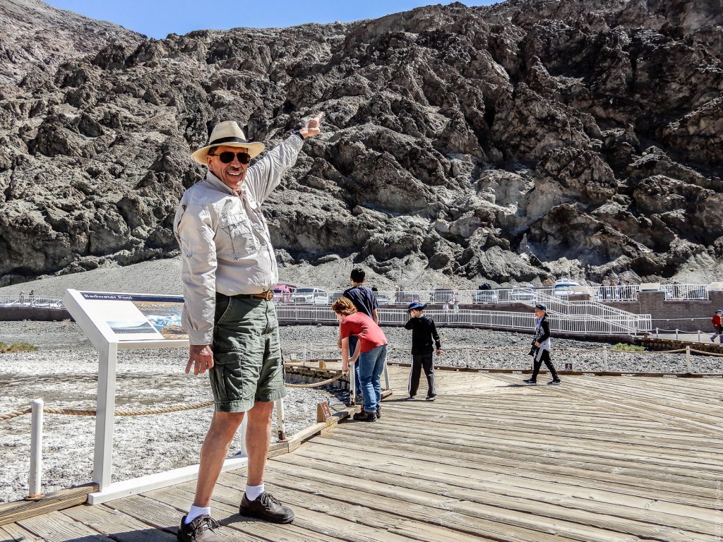
Author at Badwater Basin (26 Mar 2018)
To put some perspective on the previous photo, here I am at Badwater Basin almost one year earlier. I am standing at 282 ft/86 m BSL pointing to a sign on the cliff that says “Sea Level.” The sign does blend into the cliff but, if you squint hard, you can see it just the the right of my pointing finger. If you draw a line from my hat straight up to the top of the cliff you will see where Dante’s View is. Sadly, the camera cannot capture the vertiginous perspective of the 1.0+ mile/1.6+ km between me and Dante’s View. Nevertheless, I still find the memory of finding myself so far below sea level very exciting. Badwater Basin is the lowest point in the entire western hemisphere.

Badwater Basin (Closeup) from Dante’s View
The white salt flat is most of Badwater Basin. Where I was standing in the previous photo is not visible, just under the peak on the right where the wide white trail intersects the ridge line. Unlike the previous photo, this one captures the 1.0+ mile/1.6+ km plunge.
Pyramid Peak in a Light Snow Shower.
View from Dante’s View and looking NE. Pyramid Mountain at 6703 ft/2043 m is the high point in the Funeral Mountains and might be the poster child of a desert peak. I find it difficult to take my eyes off the sere beauty of this scene. The Nevada National Security Site (NNSS), previously known as the Nevada Test Site (NTS) lies immediately beyond the obscured mountains in the distant background.

Black Mountains in Lower Death Valley
From Dante’s View and looking due south. The ridge line of the Black Mountains runs from the left and across the middle of the photo before it descends to the salt flat on the floor of lower Death Valley. Smith Mountain at 5915 feet/1803 m) is the high point along the ridge line just before the descent into the valley. Atmospheric scientists refer to clouds that are formed by mountains as orogenic. Notice the beautiful orogenic clouds formed by the Black Mountains. By the way, I am standing at the north end of the Black Mountains and can see clear to their south end. To me a most amazing part of this photo is that the San Bernardino Mountains are visible at 148 miles/238 km away. Let your eyes come down the ridgeline from Smith Mountain to a little pip on the ridgeline and you will see the light blue line of the San Bernardino Mountains where San Gorgonio Mountain is.
Loved the pictures of Death Valley! I will probably never get there, but your photos and descriptions make me feel as though I have been there!
I am very grateful to you for following the blog! My very goal is to highlight wonder in the world wherever I encounter it. Your comment says that I may be succeeding. Thank you!
Even though this was a short post, it was exciting to follow each direction and locate the relative points of Death Valley. It was almost like being there! Having the 3D model of the valley and mountains helped to put each photo into perspective. You sescribe directions well, Mike. I liked the part about “straight up from your hat…”
Thank you very much for looking at and commenting on my posts! Because you are such a wonderful artist, I treasure your feedback.
Again, Michael, you’ve captured the imagination with your narrative. The visuals are the icing on a delicious cake!
Thank you! I am thrilled that my essays have connected with you.!